Stamford Mill River Corridor River Restoration, Park & Open Space Project

:: Summary


:: Implementation

:: Background

:: Challenges

:: Planning


:: Flooding Chronology


History of Mills on Mill River   (1.24 mb)

Summary

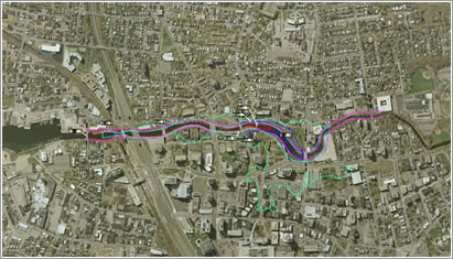
The Mill River is located in the heart of urban Stamford.  An audacious plan calls for the restoration of the river, expanded flood plain, open space and park development with greenbelt connections to Long Island Sound and north along the Rippowam River.  Included in the project is the removal of a dam and associated walls, dredging of contaminated materials, all leading to a restored river channel and riparian edges.  The Mill River Corridor Project envisions a 26-acre park and greenway along a 1.9-mile.

click image for larger view

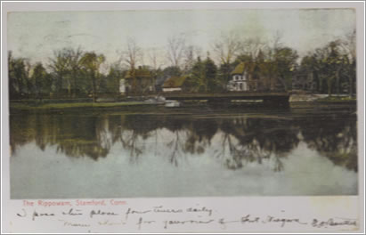
The healing effects that the river and its green banks can have on the urban soul are suggested by the inscription at the bottom of this 1800s postcard – "I pass this place four times daily."


stretch of the river and a new common ground for the Downtown and West Side communities.  The greenway will offer residents and downtown workers an accessible combination of recreation and interaction with nature. The Mill River Collaborative has been established to help manage and develop the park.

Background


ˆ top ˆ


As the Rippowam River enters its last reach before the Stamford Harbor, it slows into the impounded Mill Pond, spills over the historic dam above Main Street. The lower reaches of the Rippowam came to be known as the Mill River over the years.  The Rippowam River watershed drains 37.5 square miles that extend from  just north of the New York line to Long Island Sound. Approximately 75% of the Rippowam watershed is in Stamford. 

click image for larger view

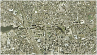
Tidal range into Mill River


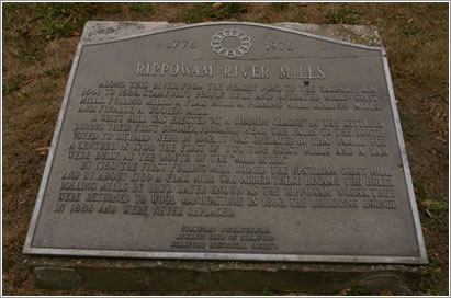
The Mill River and its historic dam served an important function as the source of power for mills, with the first dam and gristmill constructed in 1641.  The plaque shown below reads:

1776 to 1976
Rippowam River Mills

Along this river from the nearby pond to the harbor Stamford’s people built and operated mills – grist mills, fulling mills, a flax mill, a planing mill, rolling mills, and finally a woolen mill.

A grist mill was erected “at a common charge, by the settlers during their first summer, probably near the falls to the south. Voted to Richard Webb in 1662, it was operated by that family for a century. In 1708 the first of two tide grist mills and a dam were built at the mouth of Mill River.

In 1760 the first fulling mill joined the upstream grist mill and by about 1789 a flax mill was added. These became the Holly Rolling Mills by 1937. Later known as the Rippowam Works, they were returned to woolen manufacture in 1862. These buildings burned in 1886 and were never replaced.

In 1922, the dam was rebuilt (Ambursen Dam) and the pond encased with walls in order to meet the requirements of an abutting industrial firm, the Diamond Ice Company.  The company closed down operations around 1960 (the pond was also an attraction for ice skating. Substantial freezing no longer occurs.

click image for larger view
 

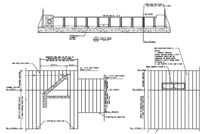
The mill site, including the dam, was later sold to the Stamford Housing Authority for public housing.  Recently, title to the dam was transferred from the Housing Authority to the City. The dam prevents the passage of anadromous and freshwater fish species, including river herring.

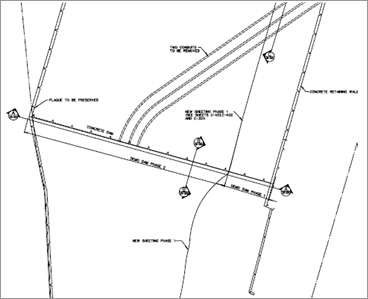
Plan view of the “Ambursen” dam at the Mill Pond


A considerable portion of the land adjacent to the river is impervious and storm drains from adjacent streets drain directly into Mill River.  The combination of urban development and structural restrictions to the river, has caused the aquatic habitat of the Mill River to be degraded.  The Mill Pond contains an excessive amount of sediment and is shallow and choked with invasive aquatic plants and decomposing organic matter.  In other reaches of the river invasive plants have spread and now dominate much of the riparian edge and marsh wetland habitats.

click image for larger view

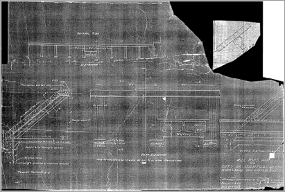
Elevation views of the dam

 
click image for larger view

Historic plans for the dam


Historically, development along the river had lots facing neighboring streets and with their backs to the river.  The riparian banks of the Mill River have been frequently encroached upon by residential backyards, parking lots and buildings.  To the west is the predominantly residential West Side neighborhood and to the east a small residential enclave along Clinton Avenue and Stamford’s Downtown.  Within one mile of the Mill River reside half of Stamford’s 121,000 residents and the majority of the city’s office work force is within walking distance of the river as is the University of Connecticut at Stamford and the Transportation Center.  Downtown Stamford has witnessed considerable development in recent years, in particular new housing.  However, no new park/open space has been created for the growing residential, workforce and student population.

 
click image for larger view

Dramatic reduction in downtown flooding will result
from removal of the Mill Pond dam and walls.


In the 1940s and 1950s, Junzo Nojima, Stamford resident and immigrant from Japan planted and cultivated the grove of Kwanzan cherry trees that came to be the most recognized symbol of Mill River Park. His single handed gift to the City and its residents earned him a place among the Heroes of Stamford and his story is depicted in a book that can be viewed at the Stamford Historical Society. The Historical Society is the source of many of the historical images shown here.

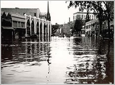
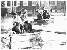
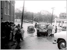
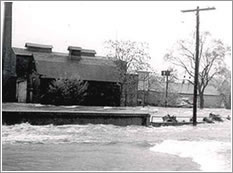
During floods (link to Flooding Along Mill River at end) the river overtops its banks.  The limit of the federally designated 100-year flood extends across Washington Boulevard east into the Downtown. In October 1955, a record two-day rainfall caused extensive flooding and property damage in downtown Stamford.  Another significant flood event occurred in 1972.  In both April and October, 2007, 50-year flood events caused the closing of Washington Boulevard, Stamford’s primary north-south artery, as well as flooding to the north and east. Damage from these floods reached into the millions of dollars. Removal of the dam and planned park landscape changes will reduce the 100-year flood levels in downtown by 3 feet and largely contain such floods within the park south of North Street.

Planning


ˆ top ˆ

In 1929, Herbert Swan produced Stamford’s first Master Plan that included new open space and parkland along the Mill River.  During the 1970s and 1980s a number of flood studies were prepared by the Army Corps of Engineers and State of Connecticut.  Among the alternatives recommended was a by-pass tunnel.  The city declined to accept these recommendations, due to the negative impacts on the environment and recreation.

In 1976, the City issued a report entitled, “Mill Pond.” The report recommended the creation of a riverside park and the dredging of the Mill Pond.

In 1979, the City published a report entitled, “The Mill River Greenbelt Study.”  This report studied the feasibility of creating a continuous river walk and linear greenbelt.  Stamford initiated the implementation of the study by acquiring some land along the river.

In 1997, the City hired Sasaki Associates to produce a comprehensive study of the Mill River Corridor.  While prior studies had limited their focus to the river and its immediate banks, it was recognized that the river and potential park and open space should be viewed as part of the adjacent urban fabric and planned in conjunction with the development potential of the entire corridor. This eight months study, which included public forums, resulted in the Mill River Corridor Plan. Key project goals included:

  • To reclaim and enhance an environmental and open space resource in the heart of the city.
  • To clarify the future of the area in relation to catalyst projects and development pressure in the corridor.
  • To build a constituency for the Plan on both sides of the river.
  • Create a civic gathering place for the city.
  • Maintain the ability to extend a trail system to the north and south.

The Sasaki Plan recommended that within the Corridor, nineteen (19) acres of new open space were to be added and another seven (7) acres upgraded to create an open space and park system in the heart of Stamford.

Following the completion of the Mill River Corridor Plan, Mayor Dannel Malloy instructed the land use boards, Urban Redevelopment Commission and staff to propose implementation tools to bring the Plan’s recommendations into fruition.  Over the next several years, the following regulatory tools were put into place:

  • The Master Plan was amended by the Planning Board
  • A new zoning district (Mill River Design District) was created by the Zoning  Board
  • The Corridor was designated as a redevelopment area by the Board of Representatives and a project plan was adopted by the Urban Redevelopment Commission.
  • City capital accounts were established for both property acquisition and park development.

In 2000, the city contacted the Corps of Engineers requesting that ecosystem-restoration opportunities along the Mill River be studied by the Corps under Section 206, Aquatic Ecosystem Restoration Program.  The Corps report, which took three years to complete, evaluated a number of alternative actions based on the following criteria:

  • Restore anadromous fish (saltwater fish that spawn in fresh water) passage to the upper reaches of the Mill River.
  • Improve aquatic diversity and health in Mill River.
  • Reduce sedimentation into Mill River.
  • Restore wetland habitat.
  • Improve recreational access and opportunities along the river corridor.

The chosen alternative, endorsed by both the Corps and city, consisted of the removal of the dam, concrete retaining walls, contaminated sediment, and the restoration of a natural stream channel, thereby opening up 4.5 miles of riverine habitat to anadromous fish; restoration of one acre of tidal wetlands and riparian habitat restoration along with a contiguous system of trails and outlooks.  Restoration design for the Mill River included both traditional hydraulic analysis and a more recent approach called natural channel design (Rosgen, 1996).  A further objective was to use bioengineering techniques, wherever possible, to promote bank stabilization with native vegetation.

In 2005, Stamford hired the design team led by Olin Partnership to develop the vision for the park into a Master Design Plan and to coordinate with the Army Corps of Engineers and City in the development of detailed plans for the restoration of the river and the creation of the Park.

Implementation


ˆ top ˆ

To date, implementation has consisted of the following:

Regulatory framework - On November 7, 2001, Stamford’s Board of Representatives overwhelmingly approved the plan for the Mill River Corridor.  As previously noted, the city has approved a series of land use measures including master plan and zoning amendments to facilitate the Mill River project.  Several of these actions were appealed to the Board of Representatives and court without success.  A Connecticut Department of Environmental Protection (DEP) permit was obtained for phase I of the trail and permit applications for the Corps project have been filed.

Funding - The City is using a combination of annual allocations from the capital budget, tax increment financing, state and federal grants, private contributions and land donations from developers to cover the project’s cost.

Acquisition of Properties - Over the years, the city has purchased nine properties along the river.  The properties, critical to the development of a continuous greenbelt, have ranged in size from ¼ acre to slightly more than one acre.  Acquisition costs in Stamford’s urban core are high and to date the city has spent $4.2 million on property acquisitions.  In addition, Stamford has aggressively and in most cases successfully, sought state and federal funding for open space acquisitions--$2.5 million in state and $1.6 million federal funds.

Using an innovative zoning technique, whereby a commercial developer contributes land to the city in return for height and density bonuses, Stamford obtained additional properties along the river valued at $1.6 million.

Park Improvements - Phase I of a multi-use trail was constructed in 2005.  Eighty percent of the cost was funded by a federal (STP Enhancement) grant with the city paying for the remaining costs.

In 2006, Mill River Playground was constructed.  This facility was community designed and community constructed with over 1500 volunteers participating in a seven day construction marathon. 


Challenges


ˆ top ˆ

As in any project of this magnitude and complexity, there are many challenges ahead.  At present, the top priority is the river restoration/dam removal project.  While the city’s local share of the costs (42%) the federal share is dependent on congressional “earmark” appropriations.  In the event that federal funds are not made available, Stamford will have to decide whether to move ahead with municipal funding for this $8.5 million project. 


Flooding Along Mill River: Chronology


ˆ top ˆ


September 1938 – Hurricane Edna, “The Great New England Hurricane” was the worst disaster for Connecticut in the 20th century. Prior rains on September 12 and 15 had raised the water levels, and a storm raging September 17 through 20 added another 6 inches or more of rainfall. Thus, when the hurricane hit on September 21, the water from the rains had nowhere to go. With no effective hurricane warning system in place, the combination of storm, floods, and the lack of preparedness, was devastating. Winds of 186 mph and a tidal wave of 15 to 30 feet ravaged the coast. “Stamford damage Exceeds Millions” - The Advocate.

August 1954 – Hurricane Carol is the most destructive hurricane to strike New England since Edna in 1938. 

October 1955 – Flood. Back-to-back hurricanes Connie and Diane bring storm surges and 26 inches of rainfall totally flooding downtown areas along the river. “Number of Dead May Reach 30, Damage ‘Billions’” – Headline

March 1955 – New England New York Inter-Agency Committee completed a comprehensive survey of land, water and related resources of the region. The report completed before the record flood of October 1955, presented flood control measures for the basin including channel enlargement for the lower 3 miles of the river. This plan was not economically justified and a warning and evacuation plan was recommended.

1956 – Army Corps of Engineers conducted an investigation of possible reservoir sites. The sites in the lower river were not “economically justified” while those on the upper river offered limited flood control.

1963 – The State Water Resources Commission conducted flood control channel improvement studies of the Rippowam River. Hydrologic and Hydraulic studies were conducted on the 2.8 mile lower reach and a flood control plan consisting of earthen levees, floodwalls and related structures was developed.

June 1972 – Flood

April 2, 1973 – Letter to City from Army Corps of Engineers recommends a comprehensive basin analysis rather than a piecemeal approach.

1973 – Army Corps of Engineers engaged by US Department of Housing and Urban Development to perform a flood insurance study for the City.

October 10, 1974 – Committee on Public Works of the House of Representatives, at the request of local interests, adopted a resolution requesting the study of the flood and associated water resource problems in the Rippowam River Basin.

June 1979 – Army Corps of Engineers held a public meeting entitled Flooding on the Rippowam River and How to Control It. The Corps’ printed material stated that, “If no action is taken, a repeat of the record 1955 flood could produce damages of more than $23 million. No estimate of human loss and suffering is possible.” Structural recommendations developed by the Corps were not implemented.

click image for larger view


click image for larger view
 
click image for larger view
 
click image for larger view
     

February 1981 - The Army Corps of Engineers held an environmental scoping workshop on Rippowam River Flood Control. It was the first step in defining the scope of an environmental impact statement.

1980s and 1990s – Stamford’s acquisition of property along the Mill River increased with matching funding from CT DEP.

2001 – As part of Stamford’s designation as a Brownfields Showcase Community US EPA granted $100,000 set-aside for the Army Corps Mill River Project.

Summer 2004 - the Army Corps of Engineers released its recommendation for management of the Mill River. The Corps recommended removal of the Mill Pond Dam and concrete walls and the natural restoration of the river and creation of a new floodplain within open space acquired and to be acquired by the City. The report cited major reductions in flood risk as a benefit of the dam removal under its Section 206 Habitat Restoration Program.


February 2007 – Mill River overflows its banks in a 20-year flood event.

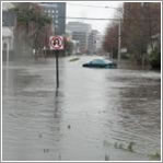
April and October 2007 – Mill River experienced 50-year flood events that closed Washington Boulevard, the main north/south artery in Stamford, stranding cars, flooding homes, nursing homes, senior complexes and other facilities. All of these impacts, above the Mill Pond dam, would be mitigated by the proposed river restoration and dam removal.

Historic post cards and pictures courtesy of the Stamford Historical Society

ˆ top ˆ


Photo Credit: Sue Sweeney