This is typically a relatively undisturbed
segment of the same river either upstream or downstream of the project
area. Alternatively, a segment of a different river with an identical classification
located in the same landform can be used for this purpose. Because the area
downstream of the Mill River dam is tidally influenced, measurements were
taken of the channel’s morphology (form) in the reach immediately upstream to
better identify various dimensions (e.g., channel width, depth, and gradient) and
characteristics (e.g., size of stones occurring in the channel) applicable to the
restoration design.
Upstream measurements were combined with flow data
from both the Mill River watershed and the New England region to determine
anticipated flood flows and flood elevations for a variety of storm events.
This information then was used to design the channel dimensions for the
restoration reach.
One of the goals of the river restoration design was to minimize the use of
streambank armoring as a means of preventing bank erosion. Instead, the
goal was to use bioengineering techniques wherever possible to promote bank
stabilization with vegetation. The design team felt this would increase both the
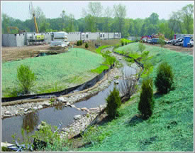
natural aesthetics and wildlife habitat value of the project. Toward this end, the project will make extensive use of livestakes, branch layering (fascines), and
container grown woody vegetation installed within coconut fiber (coir) blankets
and logs to provide both immediate and long-term bank stabilization. In some
areas where floodplain is limited and banks will be steeper, the design incorporates
the use of vegetated geogrids, permanent soil retention structures that
provide a footing for vegetation establishment.
An additional consideration in the channel design was that the restoration reach
lies within an urban park; and although streams are naturally dynamic and tend
to shift positions within their floodplains, this was not a desirable outcome within
the park setting. Therefore, the channel includes frequent use of various
types of rock vane structures (e.g., cross vanes, j-hook vanes) that control both
the elevation and location of the channel, and reduce bank erosion on meander
bends by forcing higher flows toward the center of the channel. The vanes also
maintain the structure of pools within the channel and thus enhance habitat for
aquatic biota, including fish. Lastly, several of the vanes will provide foot access
to the river itself for park visitors.
Superimposed on the bank stabilization techniques are a palette of floodplain
adapted native plant materials, including trees, shrubs, and a seed mix, and
herbaceous plugs. |
 |


|